The Oval Regeneration, Vardon Road, Stevenage
The Oval Regeneration reimagines the Oval as a new neighbourhood centre that is welcoming, a focal point for the community, and a place that people want to inhabit. The masterplan reworks the existing Radburn layout into a series of more traditional streets and public spaces with new buildings, homes, shops and community facilities addressing and activating the new public realm.

Above. existing aerial view of the Oval Centre and Hobbs Court to the south west;Rock Townsend led a multi-disciplinary team in the design and coordination of the new masterplan that incorporates up to 341 new dwellings, up to 10 small retail units (1,475 SqM), a supermarket (2,650 SqM) and a community centre and church (1,640 SqM).
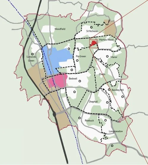
In 1946, Stevenage was selected as the first of eight 'new towns' planned around Greater London to address the post-war housing crisis. Development began with the first houses in Broadview in 1951, and the town centre was completed in 1956, officially opening in 1959. The Oval neighbourhood centre, part of the 1947 masterplan, was built in the mid-1960s, with its shopping parade opening in 1969.
New Town Vision
Lewis Silkin, the political architect behind Stevenage, envisioned a community inspired by the Garden City Movement, emphasising access to green spaces, sports, and leisure. His innovative approach included pedestrianised town centres and cycleways for sustainable transport. The town's layout combined Garden City principles with the Radburn Concept, separating pedestrian and vehicular routes. At The Oval, houses and shops face pedestrian paths, while vehicles access the rear, a design now considered flawed due to poor surveillance and a weakened public realm.
Today The Oval neighbourhood is one of twenty-two neighbourhood centres that serve Stevenage. Located in Pin Green to the north-east of the town and within the ward of Martins Wood, the Oval has been identified for regeneration within the Local Plan: H01/18 – Housing Allocation: The Oval; and HC1/7 - New and refurbished leisure and cultural facilities.

The masterplan aims to reimagine The Oval as a network of traditional streets and public spaces framed by new buildings. The plan introduces perimeter blocks that face outward, addressing the streets with active frontages. The layout is structured into distinct character areas that has informed the design of the streets, spaces, and buildings to create a cohesive and legible sense of place.
Critically the public and private realm is more clearly defined, reducing uncontrolled permeability and concentrating public activities along the streets while creating secure, manageable spaces for residents.
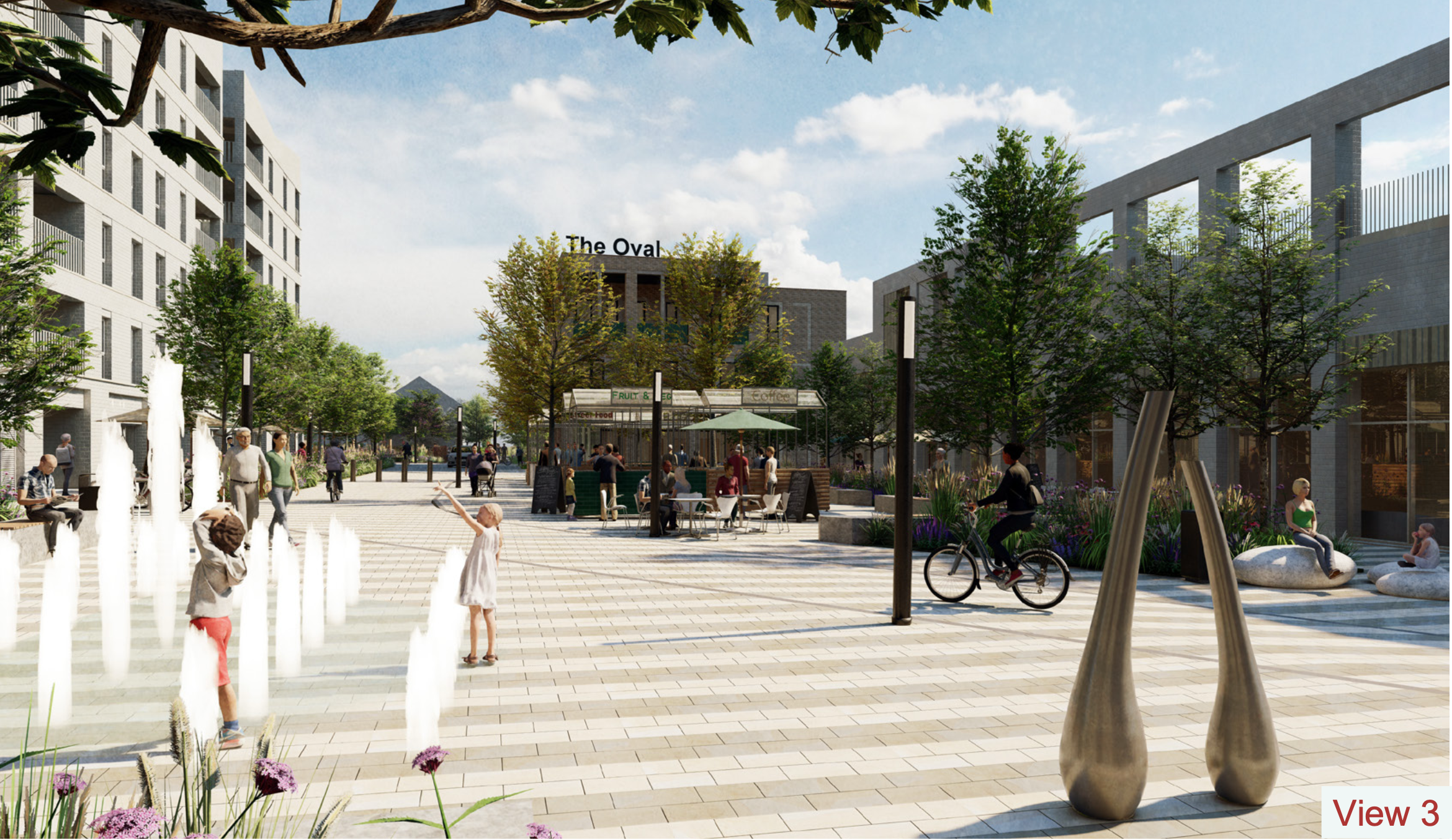
The Market Square is at the heart of the regeneration with a sub-character area of the gateway entrance at the southern end of the square. The play street is an elevated route east-west connecting the surrounding neighbourhood directly into the market square. To the north of the square, a cluster of parks and a community garden are integral to the Community Centre and replacement All Saints’ church.
The existing Jessop Road is to be transformed into a ‘green street’ with rain gardens and street planting while a new east-west route of ‘New Street’ will respond to the split character – residential to the west and commercial to the east.

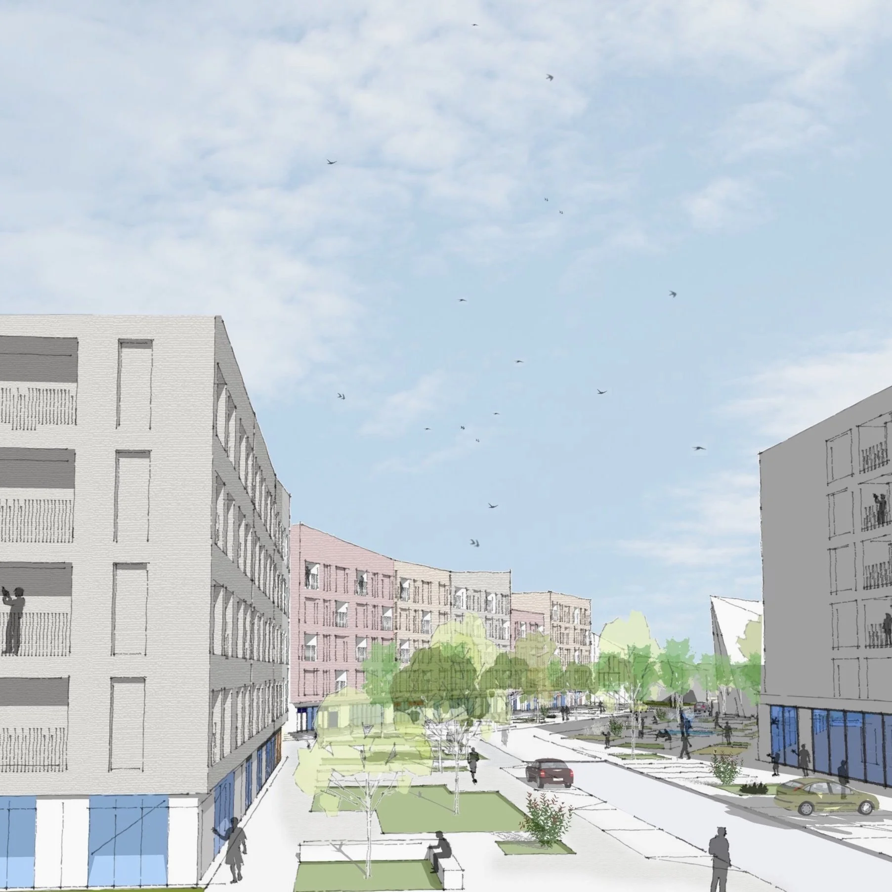

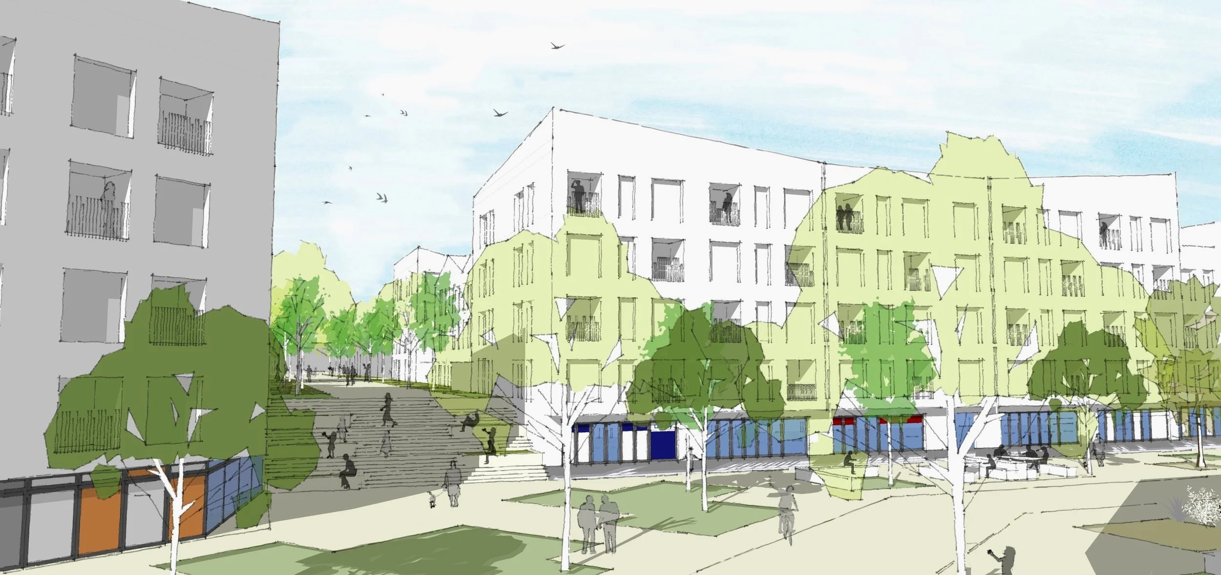
Above. stage 1-2 - indicative views of the proposed market stage ; Right. identifying the public realm works between the developable land parcels; Above. proposed design for elevated 'play street' and Spanish steps; Above. proposed design for All Saints Church.
Above. landscape character areas; Right. The masterplan for 6 developable land parcels A-F and new public realm.Landscape design & character areas
The landscape design by fabrik includes a series of diverse and contrasting spaces to serve residents and the wider community.
©fabrik
The Entrance Gateway serves as the primary pedestrian access point from the south, offering a welcoming transition into the public realm and establishing a green frontage to Market Square. This area is designed to foster gathering, relaxation, and enhance the overall sense of arrival.
A tree-lined, pedestrian-priority green avenue emphasizes walkability while accommodating occasional vehicular access. The south-facing public lawn offers a sunny, open space with ornamental planting and granite-edged seating, creating a comfortable area for relaxation. Cycle stands are strategically placed near retail entrances to promote sustainable transport. The shared surface for vehicles provides a one-way access road, with removable bollards controlling entry to the market square. Vehicles are allowed for market setup and evening activities, while emergency vehicles have unrestricted access at all times. Large planters with integrated seating near the entrance help manage vehicle flow and introduce functional greenery to the space.

©fabrik
Within the Market Square a controlled traffic zone will limit vehicle movement, prioritising pedestrian access while allowing one-way service vehicle access during the day and providing general access at evenings based on local needs.
The square's distinctive paving palette enhances its unique and memorable aesthetic, reinforcing the sense of place and identity. This is further complemented by abundant planting and a dense grid of trees, creating a green and inviting environment. The central space is designed for flexibility, hosting activities such as markets, social events, and community gatherings.
A prominent water feature, integrated into the landscape, serves as both a playful attraction for visitors and a functional element of the site's sustainable drainage system (SUDS).
Retail units will include spill-out spaces that encourage outdoor seating and engagement, contributing to the square's lively atmosphere.
Overall, this multifunctional design promotes a vibrant community space, fostering neighborhood activity, social cohesion, and economic vitality.
©fabrik

©fabrik

©fabrik
‘Play street’ is a new ‘at grade’ pedestrian route between the existing neighbourhood to the west and the new neighbourhood centre. With existing and new homes addressing ‘play street', it is now a well-surveyed public space integrated with the new pavements of Jessop Road/’Green Street’ and beyond. At the eastern end steps and ramp descend to the Market Square, creating an opportunity for the steps to become a public space in their own right, capable of being steps or seats for an event within the square
©fabrik

©fabrik
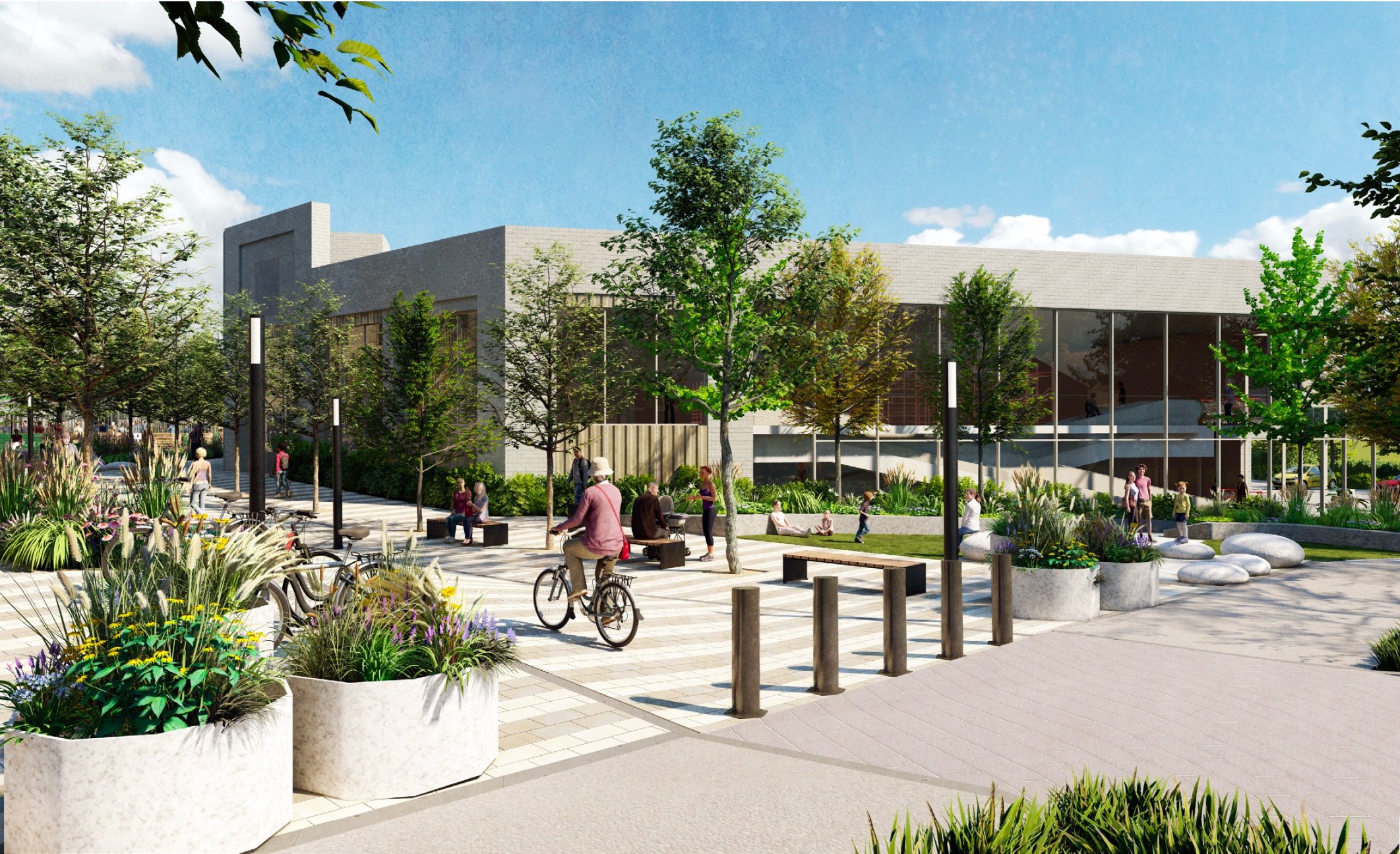
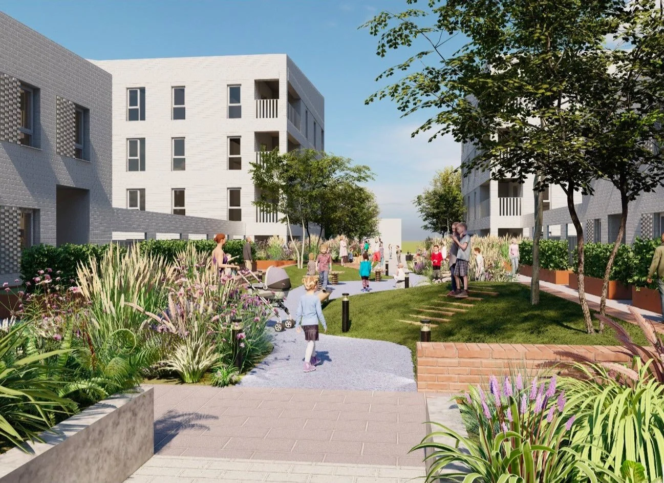
The community center and church is to be relocated within Parcel F surrounded by a carefully designed landscape parks and community garden. Comprising two play areas—located to the north and west of the community center—and a secure community garden to the east.
The play area to the west is designed for children aged 5-11, featuring adventure play equipment and he play area to the north caters for young adults aged 12-17. The redesigned community garden will remain in its current location and will be managed by the community center.

©fabrik

©fabrik
‘Green street’. Jessop Road is currently a vehicular route between Vardon Road and Martins Way, serving the residential neighbourhood to the west. It is stark, with few pavements, and lacks cohesion. The proposed masterplan seeks to activate the road with pavements on both sides, formalised parking spaces, tree planting, and buildings that address and are accessed from the street. The masterplan also looks to elevate the current pedestrian underpass so as to cross Jessop Road at grade. 'New Street’. To the north and east of the site, ‘new street’ serves a terrace of the town house, the community building, and connects around to provide access to land parcel C and Vardon Road.

©fabrik

©fabrik
Land parcels
With the desire line, circulation routes and character ares identified, the 6 land parcels, A-F have been designed to the brief:
The outline proposal for land parcel A is for residential dwellings, Use-class C3, with associated amenities and parking. For land parcels B and D, the proposal is for a mixed-use development with residential dwellings at upper levels and retail space, Use-class E at lower ground level alongside the residential entrances, parking, and associated ancillary spaces. The illustrative design proposes 236 apartments and 6 retail spaces, while the outline application seeks an upper limit of 250 dwellings and 1,200 m2 of retail. [Outline design]
The outline proposal for land parcel C is for a retail development, Use-class E, comprising small retail units, a supermarket, and car parking. The illustrative design proposes up to 225 m2 of small retail units, up to 2,650 m2 of supermarket, and undercroft parking of 1,375 m2 (or up to 50 spaces). [Outline design]
The detailed proposal for land parcel E is for residential, Use-class C3 designated for independent retirement living with communal facilities, staff welfare facilities, and associated parking and landscaping. The 91 apartments, 60 one-bedroom and 31 two-bedroom, are arranged over one to five floors and a secure, landscaped courtyard. [Detailed design]
The detailed proposal for land parcel F is for a church and community centre, Use-class F1 and F2, respectively. The gross internal area of the building is 1,614 m2, with the reprovision of All Saints Church, located on the ground floor, measuring 258 m2, and a capacity for 200 people, and the reprovision of the community centre, 1,351 m2, arranged over 3 floors, comprising meeting rooms, office suite, function halls, kitchens, and ancillary spaces. [Detailed design]


Market Square and Spanish stepsMarket Square retail spaceVardon Road approach to Market Square


Top right. Approach from the south-east to the shopping precinct; Middle right. Approach from the west to the centre; Bottom far right. The shopping precinct; Right. Hobbs Court retirement homesDescription: The neighbourhood centre regeneration comprises a new church, community centre, retail, up to 350 houses, apartments, and maisonettes, and a new landscaped public realm including parks.
Client: Stevenage Borough Council
Site area: 3.97Ha
Status: Stage 3 - Planning
Property Consultants: Beacon Partnerships
Multi-disciplinary Lead & Architect: Rock Townsend
Planning Consultant: Smith Jenkins
Structural Eng.: Gravity Consulting Engineers
Civil Eng. & Transport: Stomor Civil Engineering
MEP Eng.: Whitecode Consulting & MWL
Landscape Arch.: fabrik
Ecologist: Ecology By Design
RT Team: Dan Bangs, Sarah Keetch, Jacqueline Lam, George Dinu, Lenny Jones, Rachel Opie, Molly McAllister.
